Industrial Drone Services
Unmanned Aerial Vehicles or Drones, and the processing analytics developed for them, are truly revolutionizing the world we live in, and how we see it. No matter the type of operation or size, leaders in all industries are finding ways to incorporate Unmanned Aerial Vehicles into their daily work flow operations. Saving lives, improving efficiencies and growing the bottom line are all made possible by the introduction of UAV services.
East Coast Drone Works offers some of the very best services and talent on the market.. "If you do not know what drones can do for you, then you have not thought about it."
East Coast Drone Works has an extensive range of UAV industrial services available.
Using only state of the art UAVs, optical sensors and imagery analytics allows ECDW to delivers high quality video inspections, Site Mapping and Monitoring services. Thermal, standard RGB and multi spec cameras are all available to fly.
We are way more than just excellent aerial photography provider; East Coast Drone Works puts state of the art aerial tools to work for you.
![]()
Image Detail at 150 Feet
Entire Site at a Glance


Site Mapping Services:
3D site maps give your team access to current aerial imagery & data from anywhere, at any time with our site mapping services Invite others from your team to review, collaborate, and problem solve with easy to share web links of current aerial imagery.

These 3D maps also make great interactive displays for investors and sales associates.
Site Management Services:
Current Maps and observation annotations can be made quickly, accurately and at any time there may be a need... Receive progress updates, manage efficiencies and identify the unexpected variables quickly, preventing the small problems from becoming large problems. Share your reports with anyone at any time via “easy to use” web links. Useful, Accurate and Timely data that only UAV aerial tools can deliver.

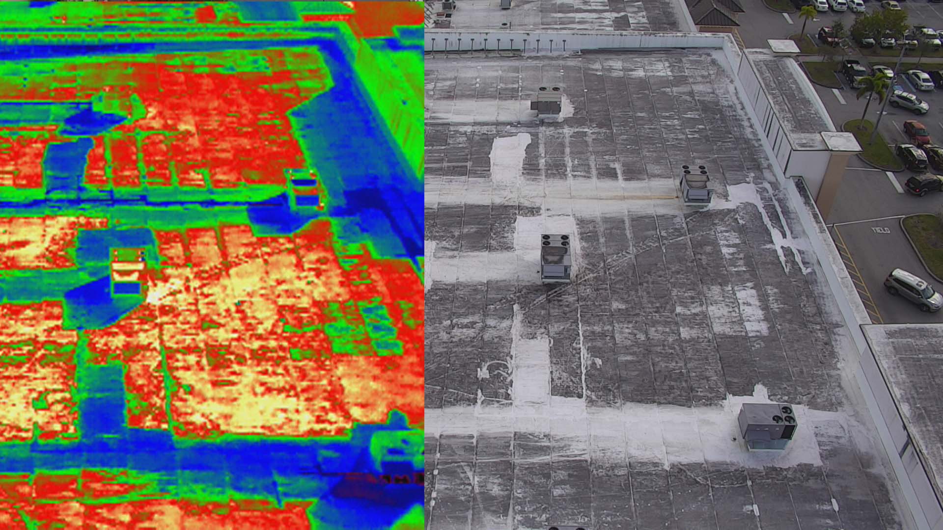
Roof & Infrastructure Inspection Services
No matter what the size of the structure or property, East Coast Drone Works has it covered with fast, accurate and actionable aerial data. In a fraction of the time that traditional ground inspections take. By standardizing the data collection process, equipment and reporting software. ECDW delivers professional, reliable reports, that can be easily incorporated into daily operations or incorporated into client presentations.
East Coast Drone Works uses some of the best optical sensors and imagery analytics on the market.
The DJI Zenmuse XT powered by Flir has a 640 x 512 resolution, 13mm lens and was born to fly. This sensor is radiometric, has a 30hz full frame rate and a 8x zoom. Real time temperatures can be accessed in flight. Image & temperature data can be stored by pixel and downloaded for qualitative temperature reports.


As the first integrated aerial camera with an optical zoom up to 30x and digital up to 6x, the Zenmuse Z30 offers unparalleled image data capture. East Coast Drone Works captures the information we require from a greater range, making image data collection significantly faster and eliminates risk of harm to both personnel and equipment.
The Z30 is the most powerful integrated aerial zoom camera on the market with a total magnification up to 180x. No matter what we are inspecting, the Z30 enables ECDW to get a detailed look at structures, wires, modules and components to detect damage, safely and more efficiently than ever before.
